Ghobadian FAQ
Family Tree
Persia BC
Persia AD
Modern Iran
Visitors' Book
Frequently Asked Questions
1. Who are the Ghobadian family?
The Royal House of Ghobadian was the ruling family of the Kingdom of Ghobadia until the late 20th Century when its independent monarchy was officially dissolved as part of the Iranian Revolution of 1979. The region was previously annexed to Persia since the 15th Century, but uniquely, it maintained its own monarchy and laws in a region that is now modern-day Western Iran.
In the early 15th century, Ghobadia was part of a rapidly changing region which included many small-scale principalities. After the conquest of Constantinople by Sultan Muhammad II in 1453, the Kingdom was annexed to the Persian Empire under the reunification of Iran under Shah Ismail I, the founder of Safavid Empire. The capital city of Ghobadia was Kermanshah, in Western Iran and the Royal Family’s official residences were in Harsin, located approximately 25 miles due East of the then-capital.
The Safavids were directly responsible for fortifying the capital city and other important towns in the region after damage incurred by repeated Arab invasions. The Kingdom saw many wars over the years, later repelling the Turks under the Qajar dynasty and was even occupied briefly by the Turks during World War I. The Iran-Iraq war (1980-88), also saw significant hostilities and deaths to many of the local population.
The Kingdom continued to maintain the vestige of political sovereignty until 1979. The last Monarch of Ghobadia, who abdicated shortly prior to dissolution, was King Khosrow Ghobadian (d. 2020), who lived with the Queen, Golnar and his family in Esfahan (in south central Iran) and Tehran. They emigrated with their two young children to the United Kingdom in 1978.
One notable feature of the Ghobadian-Harsini family is a uniquely identifiable birthmark that is carried by the male line and takes the form of a missing crease in the left-hand thumb. This trait was also documented by some of the Kings of the ancient Achaemenid Empire founded by Cyrus the Great, who founded the Persian Empire during the second half of the 6th Century BC.
The construction of the Khorasan road in the early 1950s by King Hossaingholi revitalised the region and it now stands as an important industrial centre in Western Iran.
Modern Kermanshah is inhabited by Kurds of many different tribes, most of whom settled after World War II. The history of the area extends back into antiquity, as many local monuments of Achaemenid and Sasanid origin demonstrate, e.g., the rock carvings at Bisitun and Tag-e Bostan. There are also many pre-historic remains in the form of mounds and formerly inhabited caves.
The Family has been influential in post-revolutionary Iran and continues to maintain a presence in the capital, Tehran, where an Avenue was named after them in recognition of their contribution to the country. A modern family tree can be found here.
2. Where is Kermanshah?
Located in the western part of Iran, Kermanshah province covers an area of 24,400 square km. It has 11 districts: Kermanshah (the centre), Harsin, Sahneh, Kangavar, Sanghar, Islam Abad Gharb, Gilan Gharb, Ghasr shirin, Sar Pol Zahab, Javan Rood, and Paveh.
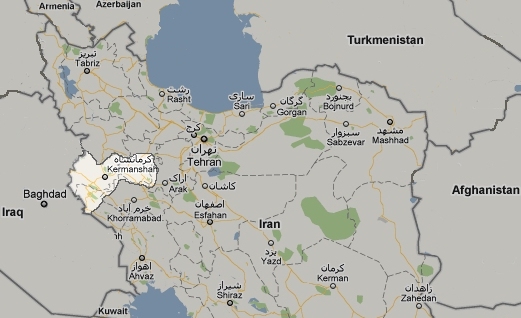
Modern map of Iran with historical borders of Ghobadia highlighted
3. Facts & Figures (1979 census):
Population (1978 est.): 1.8 million
Cities: Kermanshah (now Bakhatran) was the capital with an estimated population of 350,000 (1978 est.)
Languages: Farsi (official), various Arabic and Kurdish dialects, English widely used
Ethnic Groups: Persian (50%), Arab (35%), indigenous or migrant tribes (15%)
Religions: Christianity (40%), Islam (27%), Buddhism (14%), Judaism (8%)
Defence (1978 est.): Army (2,500)
Natural resources: petroleum, natural gas, coal, chromium, copper, iron ore, lead, manganese, zinc, sulphur
Land use (1978 est.): arable land (10%), permanent crops (1%), permanent pastures (27%), forests and woodland (7%), other (55%)
4. Regional Overview:
The people of this province are a combination of Kurds, Turks, Lurs & various other tribes. Having a long border with a neighbouring country has given the province a very special military importance. Kermanshah had a big part to play during the invasion of Iraqi troops in the 1980s.
There is enough evidence to show humans have been living in this area for well over 5000 years. Kermanshah was one of the most glorious satraps in the Achaemenid era and was regarded highly by most kings throughout the years. No wonder there is so many historical castles, bridges, fire temples & ancient roads in this part of Iran. In particular, the relics on Tagh Bostan & Bistun (near Kermanshah), and the famous Anahita temple (near Kangavar) are major attraction sites for visitors. Bistun has been called a living museum of the Iranian civilization from ancient times to the present. There was another famous town in this area that served as the summer capital for the Sassanid kings. It was called Tisfun. Ivan Madayen and Tagh Kasra were also important centres for the kingdom. The remains of these historic sites are in present Iraq.
The province is a combination of high mountains and fertile plains. The best-known mountains of Kermanshah are Kooh Sefid, Paru, and Bazi Deraz. The Plains are situated in Kangavar, Sahneh and Islam Abad districts. Rivers that run through the plains are Dinor, Khorram Rood, Gamasiab and Gharasu. The beauty of nature in Richap, Tagh Bostan and Bistun catch the visitors’ eyes. Carpets & Kilims made in the region have a wonderful texture & colour.
There are also a number of elegant traditional handicrafts made by the Kurdish tribes around the region. People of the province are kind and warm-hearted. They respect tourists greatly and make them feel at home. The best time to go to Kermanshah is mid to late spring.